


Convert GML to CityJSON: A Guide for Geospatial Data Users
Learn how to convert GML to CityJSON to make your geospatial data more accessible and easier to use.

Convert GML to CityJSON: A Guide for Geospatial Data Users
Geospatial data is becoming increasingly important in a wide range of industries, from urban planning and architecture to transportation and logistics. However, different formats and standards can make it difficult to share and use data across different systems and tools. In this article, we'll explore the process of converting GML data to CityJSON format, which can make your geospatial data more accessible and easier to use for a wider range of users.
What is GML?
GML stands for Geography Markup Language, and is an XML-based format for encoding geographic data. GML is commonly used for representing complex features in 3D space, such as buildings, roads, and terrain. GML is an open standard maintained by the Open Geospatial Consortium (OGC) and is widely used in the geospatial industry.
What is CityJSON?
CityJSON is a format for representing 3D city models, based on the JSON format. CityJSON was designed to be more lightweight and easy to use than GML, making it easier to share and use 3D city models across different tools and platforms. CityJSON is becoming increasingly popular among urban planners and architects.
Why to Convert?
There are several reasons why you might want to convert your GML data to CityJSON, including:
- CityJSON is a more lightweight and easy-to-use format than GML, making it easier to work with and share data.
- CityJSON has better support for textures and materials than GML, making it more suitable for applications such as 3D visualization and virtual reality.
- CityJSON is becoming increasingly popular among urban planners and architects, making it more likely that your data will be compatible with other tools and systems.
How to Convert
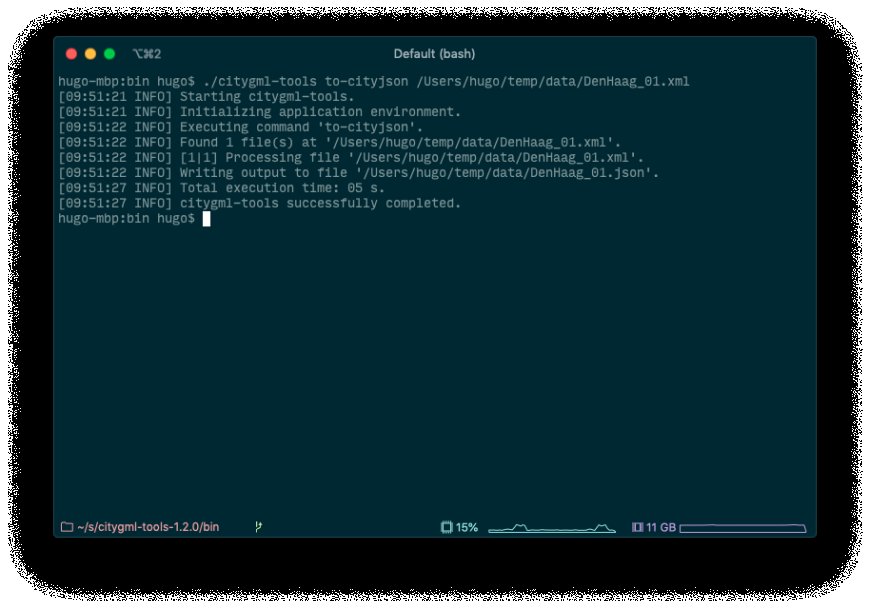
Image source:www.cityjson.org
There are several software tools available for converting GML data to CityJSON, including commercial software like FME and open source tools like ogr2ogr. Here is a general process for converting GML to CityJSON:
-
Prepare your GML data: Make sure your GML data is well-formed and valid according to the GML specification. This may involve cleaning up your data or validating it using an XML editor.
-
Choose a conversion tool: Choose a software tool that supports the specific data types and features present in your GML file. Some popular options include FME, ogr2ogr, and QGIS.
-
Customize the conversion process: Take advantage of any available options or settings to customize the conversion process to meet your specific needs. For example, you may need to adjust the coordinate system or specify certain data attributes.
-
Test the converted data: Once you have converted your GML data to CityJSON, test it thoroughly to ensure that it retains all necessary information and is compatible with your intended use. This may involve visualizing the data in a 3D viewer or using it in a GIS application.
Advantages and Disadvantages
There are several advantages and disadvantages to consider when converting GML to CityJSON. Some advantages include:
- CityJSON is a more lightweight and easy-to-use format than GML, making it easier to work with and share data.
- CityJSON has better support for textures and materials than GML, making it more suitable for applications such as 3D visualization and virtual reality.
- CityJSON is becoming increasingly popular among urban planners and architects, making it more likely that your data will be compatible with other tools and systems.
However, there are also some disadvantages to consider, including:
- CityJSON may not support all of the features and data types present in your original GML file.
- Converting may result in some loss of precision or accuracy, particularly when dealing with complex geometries or high-precision coordinate systems.
- Some software tools for converting may require additional licenses or expertise to use effectively.
Ultimately, the decision to convert this will depend on your specific needs and use case. If you are working with 3D city models and need a lightweight, easy-to-use format, then CityJSON may be the best choice for you. However, if you require a more precise or complex representation of your data, then GML may be the better option.
Conclusion
In summary, converting GML data to CityJSON can help make your geospatial data more accessible and easier to use across a wider range of tools and platforms. While there are some advantages and disadvantages to consider, CityJSON is becoming increasingly popular among urban planners and architects, and may be a good choice for your specific needs. With the right software tools and expertise, converting GML to CityJSON can be a straightforward and effective way to manage and share your geospatial data.
For more information visit Converting to/from CityGML files | CityJSON
What's Your Reaction?